 Lenticular Clouds over Plymouth, NH
Plymouth State University Meteorology Program Cloud Boutique
The Plymouth State Meteorology Program has developed this web page to provide explanations of and access to detailed pictures of some basic cloud forms. The cloud images show detailed structure and features. All of these pictures were taken in the local area around Plymouth, New Hampshire and most from the weather observation deck on the roof of the Boyd Science Center on the Plymouth State campus. Clouds can move and change shape quickly as indicated in this 30 minute time-lapse mpeg video loop. The purpose of this "boutique" is to provide a general cloud reference and is not intended to provide an all-inclusive list. Images will be added to or changed as opportunities permit.
Cloud Classification
Clouds are generally classified based on characteristics, such as, altitude, appearance, or origin. Altitude distinctions apply to those clouds that fit in various layers of the atmosphere as follows:- high clouds - have bases above 18,000 feet
- middle clouds - have bases between 7,000 and 18,000 feet
- low clouds - have bases below 7,000 feet
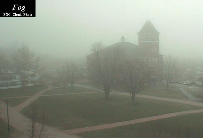
- fog - cloud in contact with the ground
- multi-level clouds... vertically thick spanning multiple layers
- orographic clouds - distinct clouds that form via interaction between wind and mountainous terrain features
Cloud Descriptions and Pictures
This section provides verbal descriptions and pictures of clouds that have been observed in this area. Because of their size, these images have been stored in JPG format. To view a picture, click on the appropriate cloud name or other highlighted text.High Clouds are primarily composed of ice crystals and include the following:
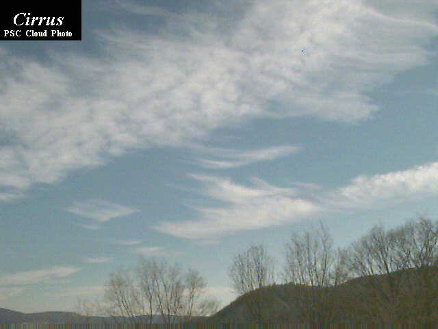
- Cirrus are high altitude wispy clouds. They are usually quite thin and often have a hairlike or filament type of appearance. The curled up ends as depicted in this picture are very common features.
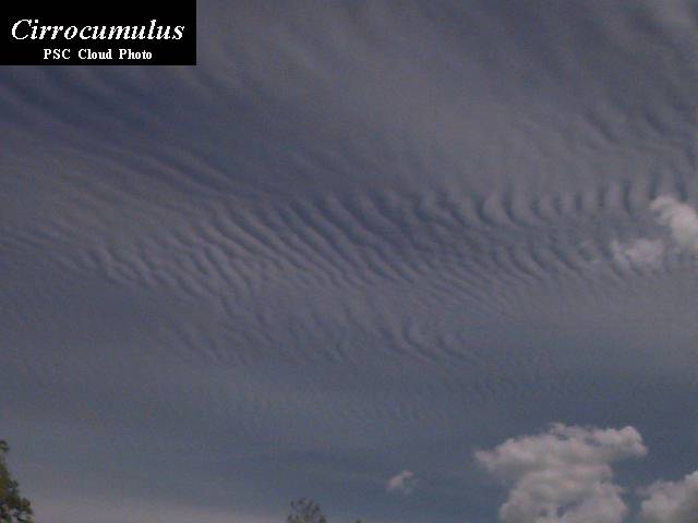
- Cirrocumulus are high clouds that have a distinct patchy and/or wavelike appearance, such as, in our patchwork cirrocumulus photo, composed of many individual cloud elements, or in our wavy cirrocumulus photo with its banded linear structure. These features are common to all types of cumuloform clouds.
- Cirrostratus are high clouds that usually blanket the sky in ill-defined sheets. These clouds are usually optically thin and the sun and moon can usually shine some light through. Like other stratiform clouds, one usually can't detect distinct cells or sharp features. This picture shows the sun shining through a gray, diffuse cirrostratus overcast.
Middle clouds have many similarities to the cumuloform and stratiform
high clouds. Since they are closer to a groundbased observer, the cumuloform
elements in particular appear larger than their high cloud counterparts.
They can contain ice crystals and/or water droplets and may occasionally
be associated with some light precipitation.
- Altocumulus have distinct cloud elements and are either in a patchy, scattered distribution or can appear in linear bands. The altocumulus in this photo by Jay Shafer consists of a number of individual cloud elements. Jay also took this beautiful sunset photo of altocumulus clouds.
- Altostratus have a more uniform and diffuse coverage where it is difficult to detect individual elements or features. In this picture, a few altocumulus clouds in the foreground precede a more uniform deck (see arrow) of altostratus.
Low clouds are most often composed of water droplets, but can have
ice crystals in colder climates. Some of these clouds can develop into
the multi-level clouds and can go through various phases, such as, a morning
stratus deck turning into late morning stratocumulus, then early afternoon
cumulus, and vertical development into cumulonimbus which can produce heavy
rain and possible lightning and thunder.
- Cumulus are usually puffy and often have very distinct edges and usually a noticeable vertical development. They often have a popcorn-like appearance. Cells can be rather isolated or they can be grouped together in clusters as shown in this photo. The main cumulus cloud pictured in this view was nearly overhead, so the vertical extent is hidden from view. However, since the sun is on the other side of the cloud, its thickness is evident from the negligible amount of light passing through its center.
- Stratocumulus can be widely scattered (as depicted in this photo, but are usually concentrated closer together in clusters or layers and have very little vertical development. This photo of a stratocumulus layer from above was taken by Jay Shafer, a Plymouth State meteorology graduate, from Mt. Washington. Jay also went down to a lower elevation and took another photo providing a closeup, side view of a stratocumulus cloud in this deck. These relatively flat clouds usually lack the sharp edges and "popcorn" appearance of most normal cumulus clouds.
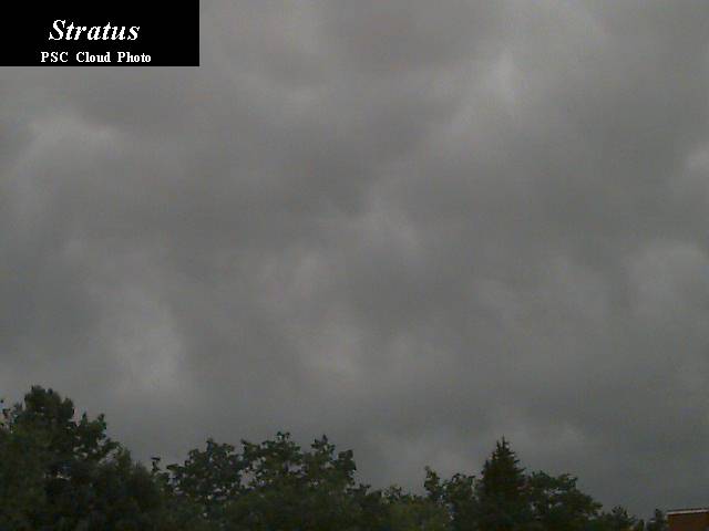
- Stratus are usually the lowest of the low clouds. Stratus often appear as an overcast deck (as shown), but can be scattered. The individual cloud elements have very ill-defined edges compared to most low cumuloform clouds (e.g. cumulus and stratocumulus).
- Fog can be considered as a low stratus cloud in contact with the ground. When the fog lifts, it usually becomes true stratus. This photo shows fog over the Pemigewasset River basin with clear skies elsewhere.
Multi-layer clouds are the heavy precipitation producers. The depth
of these clouds give precipitation hydrometeors a better environment to
develop and grow.
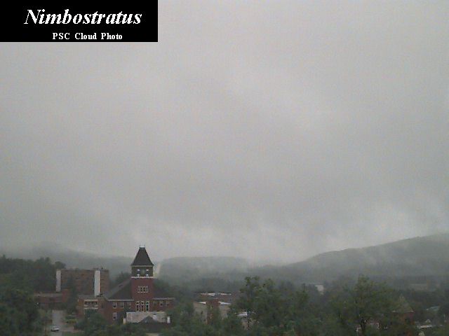
- Nimbostratus are often included in many texts as low clouds, but here they are considered multi-layer clouds because their vertical extent often goes well into the middle cloud region and these clouds often have even taller cumulonimbus clouds embedded within them. The clouds are very dark, usually overcast, and are associated with large areas of continuous precipitation. If it's a gray and rainy day as shown in this photo, the sky most will most likely be filled with nimbostratus clouds.
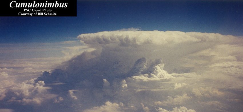
- Cumulonimbus, as shown in this photo (with cumulus in the foreground), are the clouds that can produce lightning, thunder, heavy rains, hail, strong winds, and tornadoes. They are the tallest of all clouds that can span all cloud layers and extend above 60,000 feet. They usually have large anvil-shaped tops (as shown) which form because of the stronger winds at those higher levels of the atmosphere. This first "cb" picture was taken by Plymouth State student Bill Schmitz from an airplane outside of the New York City area--note the three smaller turrets developing. Another picture shows a view from the ground of a cumulonimbus with a base at around 3,000 feet and vertical development upward to around 30,000 feet - small compared to most thunderstorms which are associated with really severe weather. Sometimes, strong cumulonimbus clouds can have appendages protruding from the base of the cloud, which are called "mammatus" clouds because they resemble the mammary glands of mammals. They indicate that the atmosphere is quite unstable and can also be an indicator of impending severe weather. The picture of mammatus clouds, shown here, was taken by Mark Gibbas, a Plymouth State meteorology alumnus, at Acadia National Park. Additional mammatus photos have also been submitted by Cindy Shannon (image) and Robert Himes (image)
Orographic clouds, as the name implies, are produced by the flow
of air interacting with mountainous terrain.
- Cap clouds form when air containing water vapor is uplifted on the windward slide of the slope and reaches saturation producing liquid water cloud droplets and a cloud which can "cap" the summit. The spectacular picture was provided by Michael Nahmias and shows the cap cloud shrouded summit of Mt. Rainier.
- Lenticular clouds are lens-shaped clouds that can result from strong wind flow over rugged terrain. At the time of this photo, the winds were blowing around 30-40 mph from right to left, forming several lenticular clouds. Sometimes they stack up like pancakes in multiple layers as are several depicted in this first photo. The strong flow produces a distinct up and down wavelike pattern on the lee side of the mountain or large hill and the lenticular clouds tend to form at the peaks of these waves. They sometimes are very round and the edges are so well defined that they resemble flying saucers. This close up sequence shows a large lenticular cloud at various stages of illumination as the sun moved lower on the horizon and lit the cloud from below. Another lenticular cloud can be seen in the background of the last frame of the sequence. These photos were taken on January 25, 1999 in Plymouth, NH, by James D. Rufo, a Plymouth State meteorology graduate. Mrs. Lorraine Brown of Bristol NH captured this same cloud formation from about 20-25 miles further away in these pictures. Lenticular clouds are often placed into the middle cloud category since they are most common at those altitudes. Plymouth State meteorology graduate, Jay Shafer, has also provided some stunning additional lenticular pictures taken around the White Mountain region of New Hampshire.
Another "specialty" cloud is one that can develop due to Kelvin-Helmholtz
(K-H) instability waves and subharmonic resonance with other waves in the
atmosphere. This can result in an intertwined or spiral cloud pattern as
shown in this picture, which was also taken
by James D. Rufo. H-H instability is the result of strong wind shear. K-H
clouds that form in early stages can resemble well-organized waves that
appear to be breaking like ocean waves.
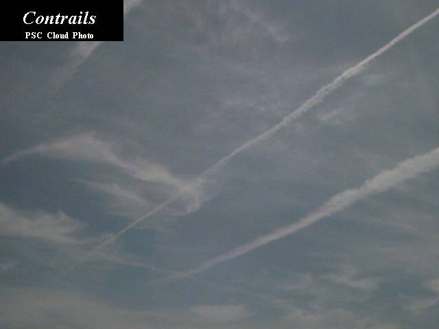
Another type of cloud can be formed from the vapor contained in the exhaust of a jet engine of an airplane when they are flying at high enough altitudes where cold temperatures cause the vapor to turn into ice crystals like cirrus clouds. These clouds are called "contrails" (short for "condensation trails") and look like lines in the sky. The photo shows two contrails. The one on the lower right was formed by a jet that flew a few minutes ahead of the jet which formed the contrail in the center. The newer contrail is narrower and hasn't had the chance to diffuse like the older one.
Another useful cloud information resource is the U of Illinois Cloud Catalog.