| Introduction: | |
|
The Plymouth State University Meteorology Program runs the National Centers for Atmospheric Research (NCAR) Weather Research and Forecasting (WRF) model (Skamarock et al. 2008) version 3.9.1 with in-house computational infrastructure that was provided by support from National Science Foundation award #1557464. The model is run once per day at 4AM Local using 0000 UTC input data from the National Centers for Environmental Prediction (NCEP) Global Forecast System (GFS) Model. Forecast data and graphics are generated out to 72 hours for three domains centered on (1) The Eastern U.S. with 27-km horizontal grid spacing; (2) The Northeast U.S. with 9-km horizontal grid spacing; and (3) New England with 3-km horizontal grid spacing (see image at right). FYI: The current UTC time is | 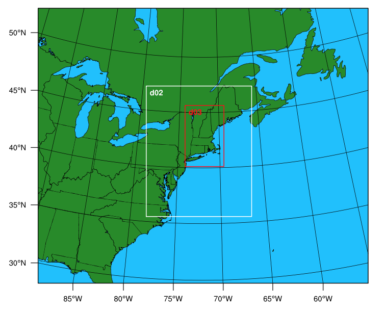 WPS Configuration |
Forecast Graphics Overview:
 |
 |
 |
 |
| Animate Forecast Graphics:
|
|
2-m Temperature and 10-m Wind Forecasts for New England:
| This Morning's Forecast | This Evening's Forecast |
 |
 |
| Click to zoom in (these images are nice and large!) (or animate). | |
Time Series Forecasts:
| Change City: Augusta, ME Bangor, ME Berlin, NH Boston, MA Brattleboro, VT Burlington, VT Concord, NH Hartford, CT Keene, NH Manchester, NH Plymouth, NH Portland, ME Providence, RI Springfield, MA St_Johnsbury, VT Current UTC time is Current Loc time is |
|
Skew-T Forecasts:
1200 UTC Today: 12-hr Forecast: |
0000 UTC Tonight: 24-hr Forecast: |
1200 UTC Tomorrow: 36-hr Forecast: |
0000 UTC Tom/Night: 48-hr Forecast: |
New Hampshire Town-by-Town WRF Summary:
 |
 |
Cold Air Damming Forecast Graphics:
- Surface Boundaries (e.g., surface potential temperature, gradient, and wind) <-- Coming Soon
- Time - Height Analyses (e.g., Temperature plotted as a function of height and forecast time at select points) <-- Coming Soon
- Time - "Latitude" Analyses (e.g., Temperature plotted versus forecast time for N-S slices) <-- Coming Soon
- Cross Sections<-- Coming Soon
Atmospheric Rivers and Orographic Precipitation Forecast Graphics:
- Integrated Water Vapor (IWV) and IWV Transport <-- Coming Soon
- Cross Sections <-- Coming Soon
Other Specialized Imagery:
Additional WRF Details:
The WRF preprocessing system (WPS) configuration included a triple nested domain centered on 42N, 72W. The outmost domain (d01) contained horizontal grid spacing of 27 km, whereas the middle (d02) and inner (d03) domains contains horizontal grid spacing of 9 and 3 km, respectively, centered over southern New England. The vertical grid spacing was every 25 hPa between the surface and 700 hPa, every 50 hPa between 700 hPa and 200 hPa, and every 25 hPa from 200 hPa and 100 hPa. The outermost domain received its boundary and initial conditions from the NCEP GFS, whereas the inner domains received their boundary and initial conditions from their parent domains. The outer (inner) domains contained 2 min (30 sec) terrain yielding a horizontal resolution of ~3.7 km (~1 km).
The 72-h WRF forecast utilized the Advanced Research WRF (ARW) with a time step of 180, 60, and 20 seconds for each domain, respectively. The physical parameterizations of the simulation included single-moment three-species microphysics (Hong et al. 2004), Dudhia and RRTM shortwave and longwave radiational physics (Dudhia 1989; Mlawer et al. 1997) ever 30 minutes, MYJ boundary layer parameterization (Janjic 1994), the Noah Land Surface Model, and Kain-Fritsch cumulus parameterization (Kain 2004) every 5 minutes over the two outer domains.
Questions?
Please contact Dr. Jason Cordeira at j underscore cordeira at plymouth dot edu.