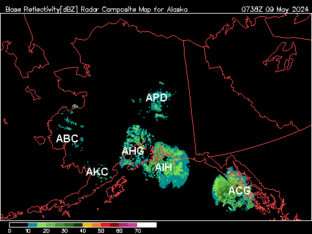
ALASKA
Anchorage, AK (AHG)
Bethel, AK (ABC)
Fairbanks, AK (APD)
King Salmon, AK (AKC)
Middleton Island, AK (AIH)
Nome, AK (AEC)
Sitka/Biorka Island, AK (ACG)
-----------------------------------------------
ALABAMA
Carrville/Maxwell AFB, AL (MXX)
Ft. Rucker, AL (EOX)
Mobile, AL (MOB)
N.E./Hytop, AL (HTX)
Shelby County AP/Birmingham, AL (BMX)
------------------------------------------------
ARIZONA
Flagstaff, AZ (FSX)
Tucson, AZ (EMX)
Williams AFB/Phoenix, AZ (IWA)
Yuma, AZ (YUX)
------------------------------------------------
ARKANSAS
Little Rock, AR (LZK)
Western Arkansas/Ft. Smith, AR (SRX)
------------------------------------------------
CALIFORNIA
Beale AFB, CA (BBX)
Edwards AFB, CA (EYX)
Eureka, CA (BHX)
Hanford AP/San Joaquin Valley, CA (HNX)
McClellan AFB/Sacremento, CA (DAX)
Mt Umunhum/San Francisco, CA (MUX)
San Diego, CA (NKX)
Santa Ana Mountains/March AFB, CA (SOX)
Sulphur Mtn/Los Angeles, CA (VTX)
Vandenberg AFB, CA (VBX)
------------------------------------------------
COLORADO
Front Range AP/Denver, CO (FTG)
Grand Junction, CO (GJX)
Pueblo, CO (PUX)
------------------------------------------------
DELEWARE
Dover AFB, DE (DOX)
------------------------------------------------
FLORIDA
Jacksonville, FL (JAX)
Key West, FL (BYX)
Melbourne, FL (MLB)
Miami, FL (AMX)
Red Bay/Eglin AFB, FL (EVX)
Ruskin/Tampa Bay, FL (TBW)
Tallahassee, FL (TLH)
------------------------------------------------
GEORGIA
Moody AFB, GA (VAX)
Peach Tree City/Atlanta, GA (FFC)
Robins AFB, GA (JGX)
------------------------------------------------
GUAM
Agana, Guam (GUA)
------------------------------------------------
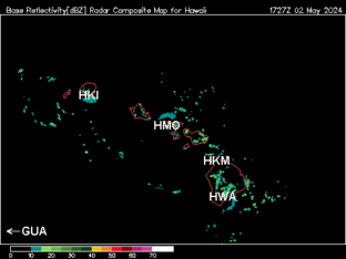
HAWAII
Kohala, HI (HKM)
Molokai, HI (HMO)
South Hawaii, HI (HWA)
South Kauai, HI (HKI)
------------------------------------------------
IDAHO
Boise, ID (CBX)
Pocatello/Idaho falls, ID (SFX)
------------------------------------------------
ILLINOIS
Central (Springfield), IL (ILX)
Chicago, IL (LOT)
------------------------------------------------
INDIANA
Evansville, IN (VWX)
Indianapolis, IN (IND)
Webster, IN (IWX)
------------------------------------------------
IOWA
Davenport/Quad Cities, IA (DVN)
Acorn Valley/Des Moines, IA (DMX)
------------------------------------------------
KANSAS
Dodge City, KS (DDC)
Goodland, KS (GLD)
Wabaunsee County/Topeka, KS (TWX)
Wichita, KS (ICT)
------------------------------------------------
KENTUCKY
Ft. Campbell, KY (HPX)
Ft Knox Mil Res/Louisville, KY (LVX)
Jackson, KY (JKL)
Paducah, KY (PAH)
------------------------------------------------
LOUISIANA
Ft Polk, LA (POE)
Lake Charles, LA (LCH)
Shreveport, LA (SHV)
Slidell AP/New Orleans, LA (LIX)
------------------------------------------------
MASSACHUSSETTS
Taunton/Boston, MA (BOX)
------------------------------------------------
MAINE
Caribou (Loring AFB), ME (CBW)
Gray/Portland, ME (GYX)
------------------------------------------------
MICHIGAN
Alpena/Gaylord, MI (APX)
Grand Rapids/Muskegon, MI (GRR)
Marquette, MI (MQT)
Pontiac/Detroit, MI (DTX)
------------------------------------------------
MINNESOTA
Duluth, MN (DLH)
Chanhassen Township/Minn-St.P, MN (MPX)
------------------------------------------------
MISSOURI
Pleasant Hill/KC, MO (EAX)
Springfield, MO (SGF)
St Charles City/St Louis, MO (LSX)
------------------------------------------------
MISSISSIPPI
Brandon, MS (DGX)
Columbus AFB, MS (GWX)
------------------------------------------------
MONTANA
Billings, MT (BLX)
Glasgow, MT (GGW)
Great Falls, MT (TFX)
Pt Six Mtn/Missoula, MT (MSX)
------------------------------------------------
NEBRASKA
Grand Island, NE (UEX)
Omaha, NE (OAX)
North Platte, NE (LNX)
------------------------------------------------
NEVADA
Elko, NV (LRX)
Las Vegas, NV (ESX)
Virginia Peak/Reno, NV (RGX)
------------------------------------------------
NEW JERSEY
Fort Dix-NJ/Philadelphia, PA (DIX)
------------------------------------------------
NEW MEXICO
Field Village/Cannon AFB, NM (FDX)
Holloman AFB, NM (HDX)
La Mesita Negra/Albuquerque, NM (ABX)
------------------------------------------------
NEW YORK
Binghamton, NY (BGM)
Brookhaven/New York City, NY (OKX)
Buffalo, NY (BUF)
East Berne/Albany, NY (ENX)
Ft Drum AFB/Montague, NY (TYX)
------------------------------------------------
NORTH CAROLINA
Newport/Morehead City, NC (MHX)
Shallotte/Wilmington, NC (LTX)
Triple West AP/Raleigh-Durham, NC (RAX)
------------------------------------------------
NORTH DAKOTA
Bismarck, ND (BIS)
Fargo, ND (MVX)
Minot AFB, ND (MBX)
------------------------------------------------
OHIO
Cleveland, OH (CLE)
Wilmington/Cincinnati, OH (ILN)
------------------------------------------------
OKLAHOMA
Frederick, OK (FDR)
Shreck Farm/Tulsa, OK (INX)
Twin Lakes/Oklahoma City, OK (TLX)
Vance AFB, OK (VNX)
------------------------------------------------
OREGON
Medford, OR (MAX)
Pendleton, OR (PDT)
Portland, OR (RTX)
------------------------------------------------
PENNSYLVANIA
Coraopolis/Pittsburgh, PA (PBZ)
Moshannon St For/State College, PA (CCX)
------------------------------------------------
PUERTO RICO
San Juan, PR (JUA)
------------------------------------------------
SOUTH CAROLINA
Columbia, SC (CAE)
Charleston, SC (CLX)
Greenville/Spartanburg, SC (GSP)
------------------------------------------------
SOUTH DAKOTA
Aberdeen, SD (ABR)
Rapid City, SD (UDX)
Sioux Falls, SD (FSD)
------------------------------------------------
TENNESSEE
Knoxville, TN (MRX)
Millington NAS/Memphis, TN (NQA)
Old Hickory Mt/Nashville, TN (OHX)
------------------------------------------------
TEXAS
Amarillo, TX (AMA)
Bracketville/Laughlin AFB, TX (DFX)
Brownsville, TX (BRO)
Central Texas (Ft Hood), TX (GRK)
Corpus Christi, TX (CRP)
Dallas/Ft. Worth (FWS)
El Paso, TX (EPZ)
League City/Houston, TX (HGX)
Lubbock, TX (LBB)
Midland/Odessa, TX (MAF)
Moran/Dyess AFB, TX (DYX)
New Braunfels AP/Austin-San Ant, TX (EWX)
San Angelo, TX (SJT)
Spinks AP/Dallas-Ft Worth, TX (FWS)
------------------------------------------------
UTAH
Cedar City, UT (ICX)
Promontory Pt/Salt Lake City, UT (MTX)
------------------------------------------------
VERMONT
Burlington, VT (CXX)
------------------------------------------------
VIRGINIA
Roanoke, VA (FCX)
Sterling, VA/Washington DC (LWX)
Wakefield/Norfolk-Richmond, VA (AKQ)
------------------------------------------------
WASHINGTON
Everett/Seattle-Tacoma, WA (ATX)
Spokane, WA (OTX)
------------------------------------------------
WEST VIRGINIA
Charleston, WV (RLX)
------------------------------------------------
WISCONSIN
Green Bay, WI (GRB)
LaCrosse, WI (ARX)
Sullivan Township/Milwaukee, WI (MKX)
------------------------------------------------
WYOMING
Cheyenne, WY (CYS)
Riverton, WY (RIW)
------------------------------------------------
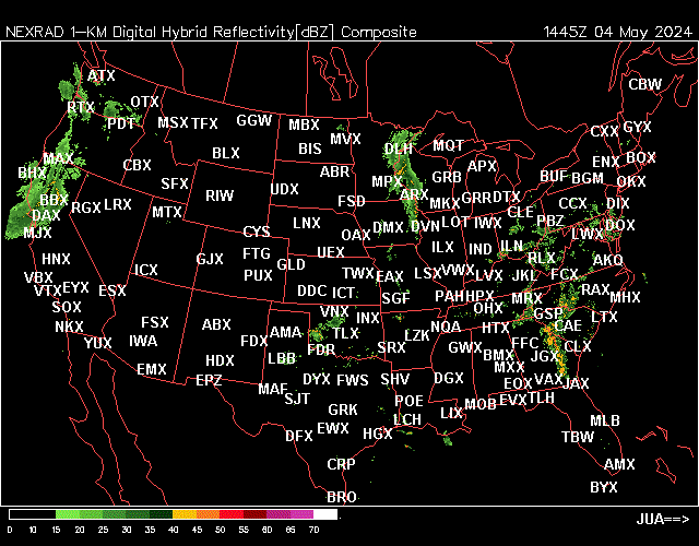
REFLECTIVITY
Digital Hybrid Scan Reflectivity (124 NM)
Digital Base Reflectivity-Tilt 1 (124 NM)
Digital Base Reflectivity-Tilt 2 (124 NM)
Digital Base Reflectivity-Tilt 3 (124 NM)
Digital Base Reflectivity-Tilt 4 (124 NM)
Digital Base Reflectivity-Tilt 5 (124 NM)
Digital Base Reflectivity-Tilt 6 (124 NM)
Composite Reflectivity (124 NM)
------------------------------------------------
ECHO TOPS
Echo Tops-1000 feet (124 NM)
Enhanced Echo Tops-1000 feet (180 NM)
------------------------------------------------
WIND-RELATED
Mesocyclone Detection (124 NM)
Categorical Base Radial Velocity-Tilt1 124 NM)
Digital Base Radial Velocity-Tilt 1 (124 NM)
Digital Base Radial Velocity-Tilt 2 (124 NM)
Digital Base Radial Velocity-Tilt 3 (124 NM)
Digital Base Radial Velocity-Tilt 4 (124 NM)
Digital Base Radial Velocity-Tilt 5 (124 NM)
Digital Base Radial Velocity-Tilt 6 (124 NM)
Storm Relative Radial Velocity-Tilt 1 (124 NM)
Storm Relative Radial Velocity-Tilt 2 (124 NM)
Storm Relative Radial Velocity-Tilt 3 (124 NM)
Storm Relative Radial Velocity-Tilt 4 (124 NM)
------------------------------------------------
MOISTURE AND PRECIPITATION
Vertically Integrated Liquid (124 NM)
Digital Vertically Integrated Liquid (124 NM)
One-Hour Precipitation(124 NM)
Storm Total Precipitation(124 NM)
Digital Storm Total Precipitation(124 NM)
Velocity Azimuth Display(VAD) Wind Profiles
2026
07
Day
13
14
15
16
17
18
19
20
21
22
23
24
25
26
27
Hour
0 Z
1 Z
2 Z
3 Z
4 Z
5 Z
6 Z
7 Z
8 Z
9 Z
10 Z
11 Z
12 Z
13 Z
14 Z
15 Z
16 Z
17 Z
18 Z
19 Z
20 Z
21 Z
22 Z
23 Z
Minute
0
1
2
3
4
5
6
7
8
9
10
11
12
13
14
15
16
17
18
19
20
21
22
23
24
25
26
27
28
29
30
31
32
33
34
35
36
37
38
39
40
41
42
43
44
45
46
47
48
49
50
51
52
53
54
55
56
57
58
59