Select a region OR a map center location (4-digit ICAO ID, 5-digit WMO Number, or lat,lon) plus zoom factor, variable, year, month, day, time, density of station coverage for map, scaling factor for plotted text, and size of map.
Notes:
- Online archived data go back to July 30, 1998 except for NCEP fronts. Data outside of North and/or Central America are limited--even more so prior to 1999.
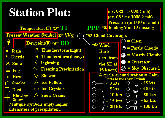
- The station plot legend is shown here.
- Archived 3-Hourly NCEP front data covering N. America start at 00Z on 9 February 2001 and end at 09Z on 1 October 2018 and resume on 1 October 2020. These archived NCEP frontal position data are available every 3 hours and are valid for 00Z,03Z,06Z,09Z,12Z,15Z,18Z, and 21Z. Choosing an intermediate hour will return data for the previous valid hour.
- Use highest density setting for most regions outside of North America.
- Station idenitiers (for centerring the map) can be specified as ICAO identifiers (e.g. KALB) or WMO number (e.g. 72518) or latitude,longitude pairs (e.g. 42.75,-73.80). This feature will center the map at that location and will enable the user to zoom in or out by setting the zoom factor. The zoom factor does not work for a standard pre-defined region.
- The 912x650 size works best for full page 8.5"x11.5" printing, if you select the landscape orientation using the "Properties" or "Preferences" option of the print window.
- The zoom function only works in conjunction with the station identifier, not with the pre-defined regions.