|
THE 27 STATES OF SKY |
|
|
|
Surface - 6,500 ft Surface - 1,981 m |
Surface - 6,500 ft Surface - 1,981 m |
Surface - 6,500 ft Surface - 1,981 m |

Low 1:
Cumulus of little vertical development, or ragged cumulus.
(Photo credit: Ron Holle.)

Low 2:
Towering cumulus (TCU): Cumulus of moderate or greater vertical development.
(Photo credit: NOAA.)

Low 3:
Cumulonimbus (CB) -- Cumulus of great vertical development (no cirrus anvil).
(Photo credit: NOAA.)

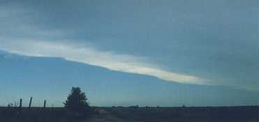
Low 4:
Stratocumulus (SC) formed by the spreading of cumulus.
(Photo credit: Jim Koermer.)

Low 5:
Stratocumulus (SC) not formed by the spreading of cumulus.
(Photo credit: Ron Holle.)

Low 6:
Stratus (ST) in a relatively continuous layer, or ragged shreds (other than that of bad weather), or both.
(Photo credit: NOAA.)

Low 7:
Low clouds in the form of stratus fractus (STFRA), cumulus fractus (CUFRA), or both, usually below altostratus (AS) or nimbostratus (NS).
(Photo credit: WMO.)

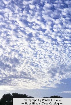
Low 8:
Cumulus (CU) and stratocumulus (SC; not formed by the spreading of cumulus)
with bases at different levels.
(Photo credit: NOAA.)

Low 9:
Cumulonimbus (CB), where the upper part of at least one of the CB clouds in clearly fibrous or striated. By convention, code figure 9 is used for Cumulonimbus Mammatus (CBMAM) and those cases in which lightning, thunder, or hail indicates the presence of a CB but the top is hidden by darkness or other clouds.
(Photo credit: Dan Bramer.)
|
|
|
6,500 - 13,000 ft 1,981 - 3,962 m |
6,500 - 23,000 ft 1,981 - 7,010 m |
6,500 - 25,000 ft 1,981 - 7,620 m |
Mid 1:
Altostratus (AS): Predominantly transparent or semitransparent.
(Photo credit: WMO.)

Mid 2:
Altostratus (AS) or nimbostratus (NS): Predominantly opaque, often associated with long periods of continuous precipitation.
(Photo credit: WMO.)

Mid 3:
Altocumulus (AC) predominantly semitransparent or tranparent at one level, not progressively invading the sky.
(Photo credit: NOAA.)

Mid 4:
Altocumulus standing lenticular (ACSL): AC in the form of semitransparent patches (often fish-shaped, almond-shaped, or lenticular) continuously changing in appearance and occurring at one or more levels.
(Photo credit: Jim Koermer.)
Mid 5:
Altocumulus (AC) progressively invading the sky.
(Photo credit: NOAA.)

Mid 6:
Altocumulus (AC) formed by the spreading or flattening of CU or CB.
(Photo credit: NOAA.)

Mid 7:
Altocumulus (AC) at two or more levels, not progressively invading the sky; or, opaque AC at one level, not progressively invading the sky; or, altostratus (AS) or nimbostratus together with AC. (Note: This code is generally used as a catch-all by weather observers.)
(Photo credit: NOAA.)
Mid 8:
Altocumulus Castellanus (ACC): Altocumulus in the form of turrets or battlements or AC having the appearance of small cumuliform tufts, with or without altostratus (AS) or nimbostratus (NS).
(Photo credit: Ron Holle.)
Mid 9:
Altocumulus (AC) of a chaotic sky, with or without altostratus (AS) or nimbostratus (NS).
(Photo credit: WMO.)
|
|
|
10,000 - 25,000 ft 3,048 - 7,620 m |
16,500 - 45,000 ft 5,029 - 13,716 m |
20,000 - 60,000 ft 6,096 - 18,288 m |

High 1:
Cirrus (CI) in the form of thin filaments, strands, or hooks (not progressively invading the sky).
(Photo credit: Dan Bramer.)

High 2:
Cirrus (CI) in predominantly dense patches or with sproutings in the form of small tufts or battlements.
(Photo credit: NOAA.)

High 3:
Dense cirrus (CI) (often in the form of an anvil) originating from cumulonimbus (CB).
(Photo credit: NOAA.)

High 4:
Cirrus (CI) in the form of hooks, filaments, or strands, invading the sky and generally growing denser.
(Photo credit: NOAA.)

High 5:
Cirrostratus (CS) (with or without cirrus) progressively invading the sky, and the continuous veil extends 45 degrees or less above the local horizon.
(Photo credit: NOAA.)
High 6:
Cirrostratus (CS) (with or without cirrus) progressively invading the sky, and the continuous veil extends more than 45 above the local horizon but does not cover the whole sky.
(Photo credit: NOAA.)

High 7:
Cirrostratus (CS) covers the entire sky. (Note: The example shown here also includes condensation trails, or contrails.)
(Photo credit: Jim Koermer.)

High 8:
Cirrostratus (CS) does not cover the entire sky and is not invading the celestial dome.
(Photo credit: WMO.)

High 9:
Cirrocumulus (CC) alone, or predominant when compared with combined sky cover of any cirrus (CI) or cirrostratus (CS) present.
(Photo credit: Jim Koermer.)
|
|