Enter a region OR a map center location (4-digit ICAO ID or lat,lon) plus zoom factor, model, model run, forecast hour, variable, station plot density, scale size of plotted data, display color scheme, map size, and web/print output.
Notes:
- MOS Data on this site are limited to the 48 contiguous US states (NAM & GFS) and Alaska (NAM_AK & GFS).
- NAM MOS and NAM_AK MOS are based on the 00Z and 12Z NAM model runs.
- GFS MOS is based on the 00Z, 06Z, 12Z, and 18Z GFS model runs.
- Not all data are available for every forecast hour. For example, maximum temperatures are only available when the valid hour of the forecast is 00Z and minimum temperatures when it is 12Z. 6-HR preciptation probabilities are available at 6-hour intervals from forecast time and 12-HR probabilities at 12-hour intervals.
- If the "latest" option provides a blank map, new data are probably in the process of arriving, so try using the "previous" option.
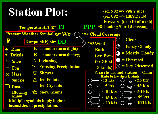
- Station plots are similar to what is described here eexcept for with MOS station plots, the number in the upper left (when available) is the probability of precipitation percentage instead of pressure.
- For raw MOS data bulletin(s) for an individual site, go here.
- This site provides meteograms and decoded text summaries for individual stations.
- You can use this current page to graphically explore possible station identifiers by selecting the "Possible Sites" option under the "Variable" menu.